Google is taking a major step toward redefining digital travel planning with the rollout of a new AI-powered feature for iPhone users. The update, quietly introduced but highly impactful, enables the Google Maps app to automatically scan screenshots saved on a user’s phone and extract location-related information, such as addresses, business names, or landmarks, and organize them into a dedicated, shareable list within the app. This innovation removes the need for manual entry and offers a seamless way to turn casual travel research into structured itineraries.
This new feature is the latest in a series of upgrades focused on enhancing how users interact with Google Maps. Earlier this year, Google announced a set of improvements aimed at digital travelers, including hotel price tracking, smarter itinerary tools, and deeper integration with Gemini—Google’s generative AI assistant. While those additions addressed broader travel planning needs, the screenshot tool focuses on a very specific, very real-world behavior: people take screenshots all the time, especially when planning a trip.
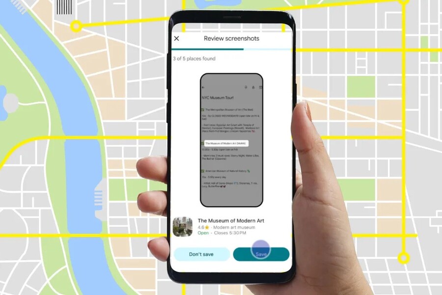
Whether it’s a restaurant suggestion on TikTok, a travel deal spotted on Instagram, or a recommendation buried in a blog post, users frequently save travel ideas as screenshots. These images often get lost in the camera roll or require extra effort to extract useful information later. Google’s new Maps feature changes that. Now, with the help of Gemini, your screenshots are automatically analyzed for potential location details, which are then presented to you for review inside the app.
When the app identifies a screenshot with useful travel data, such as a business name or a street address, it alerts the user and prompts them to confirm whether they’d like to add it to their saved places. Once approved, the location is stored in a new “Screenshots” list, visible both as a list and on the map itself. You can access and manage this list from the “You” tab in the app, alongside any other saved places or custom lists. It’s a feature built around convenience, efficiency, and intuitiveness.
Activating the new tool is a simple process. First, users need to ensure they are running the latest version of the Google Maps app on iOS. After launching the app, they can navigate to the “You” section on the bottom navigation bar. There, a new list titled “Screenshots” will appear with a “Try it out!” badge. Tapping this list starts a short tutorial explaining how the feature works. The app then requests permission to access the photos and media files on the device. Once granted, Google Maps will begin analyzing screenshots in the background.
If any screenshots contain recognizable location data, the user will receive a notification prompting them to review and confirm the saved places. This system ensures privacy and user control—nothing is saved without explicit approval. Additionally, users can initiate manual scans from within the “You” section to analyze older screenshots they may want to revisit.
The rollout is currently limited to iPhone users, but Google has confirmed that the feature will be coming to Android devices in the near future. The decision to launch on iOS first might seem surprising, given Google’s native ties to Android, but it underscores a strategy of targeting high-engagement platforms first, especially where users already demonstrate habits that benefit from automation.
This new screenshot tool is more than just a convenience—it reflects a broader shift in how people collect and process information in a mobile-first world. Screenshots have become the digital equivalent of sticky notes: quick, easy, and abundant. But until now, they lacked organization or deeper functionality. By connecting screenshots with Google Maps and empowering AI to make sense of them, Google is turning an everyday behavior into a smart planning system.
Gemini plays a crucial role here. Known for its ability to process natural language and contextual clues, Gemini’s integration means this isn’t just about recognizing addresses—it’s about understanding the meaning behind the screenshot. For example, if a screenshot shows a review snippet of a hotel with its name, city, and nearby landmarks, Gemini can piece together the location, match it to known entries in Google’s location database, and offer the user a chance to save it instantly.
It also adds a new layer of social functionality to Google Maps. Once locations are saved to the “Screenshots” list, users can share them with friends or travel companions, making trip coordination faster and easier. Whether you’re planning a group vacation, a weekend city escape, or just collecting date-night ideas, the collaborative possibilities are significant.
This feature also aligns with Google’s strategy of building more value into Maps by using AI to reduce manual labor and friction in everyday tasks. Earlier efforts in this direction include the addition of hotel price tracking, automatic itinerary syncing from Gmail, and AI-generated summaries of destination highlights. The screenshot tool fits perfectly into this pattern, helping users skip tedious steps and focus on the fun parts of planning a journey.
From a technical perspective, the feature draws on Google’s machine learning models and image recognition capabilities, many of which have matured through projects like Google Photos and Lens. These technologies are now being applied in more useful ways, tailored to common user scenarios such as trip planning.
As travel continues to rebound post-pandemic and mobile habits evolve, the demand for tools that simplify and enhance planning is rising. Consumers want smarter, faster, and more integrated solutions—and Google is positioning itself as the leader in that space. The screenshot feature might seem small on the surface, but it’s a clever and highly practical response to a common user need.
Looking ahead, the next logical step may be to expand this capability. For instance, future updates could allow Gemini to extract even more contextual data, like phone numbers, operating hours, or average ratings, from screenshots. This could turn a single image into a fully detailed entry in your travel log, complete with directions, user reviews, and suggested nearby spots. It’s not hard to imagine a future where your screenshots function as full-fledged planning objects within Google’s suite of apps.
In the meantime, iPhone users can start using this feature today. It doesn’t require any special subscription, hardware upgrade, or separate app. It’s built right into the existing Maps experience—another example of how Google continues to enhance core products in meaningful ways.
For users who rely on visual inspiration, social media discoveries, or spur-of-the-moment saves, this new tool transforms screenshots from static references into smart, living components of a travel plan. With AI doing the legwork behind the scenes, Google Maps is becoming not just a tool for getting around, but a companion in planning where to go next.